Live netcast started about 20 minutes ago. They are in the Kaiseizan Park right now.
1.4 microsievert/hour on the grass. They are saying Koriyama's radiation seems to be higher than in Fukushima City.
Live Video app for Facebook by Ustream


Live netcast started about 20 minutes ago. They are in the Kaiseizan Park right now.
1.4 microsievert/hour on the grass. They are saying Koriyama's radiation seems to be higher than in Fukushima City.
He made this observation in the latest version (7th) of his Radiation Contour Map released in July, before the Fukushima prefectural government sheepishly published the data from the monitoring posts in Fukushima taken in March last year, which does show the spikes in radiation in locations in Fukushima Prefecture not after the explosions but after the change in the reactor pressure after the vent.
Professor Hayakawa of Gunma University first put up his hastily charted map on the Internet on April 8, 2011, after the Fukushima prefectural government announced the result of the radiation measurement in schools and kindergartens inside Fukushima. The first version of the map was released on the net on April 21, 2011. I remember seeing it, and also remember he was attacked for "fear-mongering". It was around that time that Iitate-mura was officially designated as "planned evacuation zone".
In the latest 7th version, Professor Hayakawa has done two things that are new:
The map is now double-sided, and on the backside he put the map comparing the contamination from the Chernobyl accident and and that from the Fukushima accident; he also put the chronological map of contamination.
The map is available online free, like all the previous versions, but this time the printed version is being actively sold in the physical world (for 200 yen in Japan), so that people who do not have access to the net can purchase.
From the tweets that I see, it's off to a good start.
The following is my translation of the text part of the map, with review and input from the professor. Emphasis is mine:
==========================================
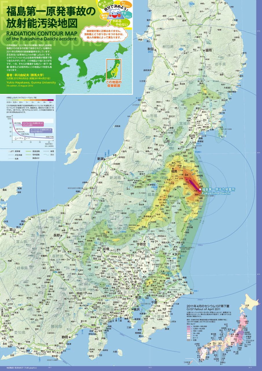
Front Page: Radiation Contour Map of the Fukushima Daiichi Accident
(Smiling blue volcano, one of Hayakawa's icons he uses on Twitter says the following)
Eat, not eat. Go, not go. Escape, not escape. Do, not do. Stop, not stop. Decide for yourself. There is no right or wrong answer to measures against radiation contamination. How to cope with radiation depends on personal circumstances.
(Text in the upper left box)
This map shows the dose rates of locations where radioactive materials that fell on the ground surface in March 2011 remain undisturbed. The values are as of September 2011, in microsievert per hour (μSv/h) at 1 meter off the ground surface of either turf or grass land. Radioactive materials get washed away from the dirt or asphalt surface by wind and rain, so the dose rates on these surfaces tend to be lower than what’s shown on the map. On the other hand, radioactive materials accumulate in rain gutters, on the ground under the roof overhang, in side drains, and on the side of the roads, resulting in the dose rates several times higher than what’s shown on the map.

Back Page: Birth of the Radiation Contour Map - What I Learned from Making the Map
(Main text, 1st row, with the Chernobyl-Fukushima comparison map)
In the afternoon on March 11, 2011, a huge earthquake and tsunami that happened in the Pacific Ocean off the coast of Tohoku destroyed Fukushima I (Daiichi) Nuclear Power Plant. For two weeks, a large amount of radioactive materials leaked from the plant. Areas as far away as Iitate-mura, 40 kilometers northwest of the plant, got severely contaminated. Nakadori (middle third) of Fukushima Prefecture, and the northern Gunma and Tochigi were also badly contaminated. Eastern part of the Tokyo Metropolitan region and southern Iwate were also contaminated. In the map on the front page, there are 8 levels of isopleths with the maximum at 16 μSv/h: 16, 8, 4, 2, 1, 0.5, 0.25 and 0.125. Needless to say, the radiation contamination extends beyond the 0.125 isopleth.
In the evening of April 8, 2011, the Nuclear Team of the Disaster Response Group of Fukushima Prefecture announced the dose rates at 1,648 schools and kindergartens in Fukushima. I found the data on the Internet, and picked one or two high numbers in each municipality, plotted on the Google Map, and made the map public that day with the three isopleths of 8, 2, and 0.5. That was the first of the radiation contour maps. Ms. Sachiko Hagiwara beautifully stylized the map, and it was published on the Internet on April 21, 2011 as the first version map (upper right).
I continued to collect information, and published the revised version on June 18, 2011. This version was the first to show the contamination in northern Tochigi and Gunma, eastern Tokyo Metropolitan region, and southern Iwate.
I revised the map every 3 months, and the current map is the 7th edition. This time, in addition to publishing on the Internet, I have decided to print on paper so that the map becomes more widely available for people who do not use the Internet.
(Main text, 2nd row, with the chronological contamination chart)
What determined the distribution of radiation contamination was the wind. Volcanic ashes from the volcanic eruption are transported by the wind at a high altitude of several kilometers and higher. However, radioactive materials leaked from the Fukushima I Nuclear Power Plant were transported by the wind near the ground surface. Looking at the meteorological data from that time period, wind directions at an altitude of 1 kilometer and higher cannot explain the distribution. I believe radioactive materials were carried by the surface wind whose altitude was dozens of meters off the ground at most. That’s the reason why the isopleths of radiation seem to follow the ups and downs of geography, such as basins and mountain sides.
The radioactive cloud that passed over Minamisoma City in Fukushima Prefecture at 9PM on March 12 continued past over Sendai Bay and reached Onagawa-cho in Miyagi Prefecture at 2AM on March 13.
The contamination on March 15 was the worst. The radioactive cloud that passed over Iwaki City in Fukushima Prefecture at 4AM reached Kanto Plain at 6AM. Since it was not raining, the cloud then headed west and north until it hit the mountainous regions in Kanto and northern part of Gunma and Tochigi Prefecture, where, for the first time, it rained, and radioactive materials came down on the ground with the rain. The contamination of Fukushima Nakadori (middle third) also happened on that day. Radioactive materials that crossed the Abukuma Mountains came down with the snow. In the afternoon, a particularly dense radioactive cloud was spewed from the nuclear plant. Carried by the wind, it went straight in the northwesterly direction, and contaminated the areas all the way to Iitate-mura, which the cloud hit at 6PM.
In the evening of March 20, areas near the Miyagi-Yamagata border and southern Iwate were contaminated. Then, the wind turned south, sending the cloud past Mito City in Ibaraki Prefecture at 6AM on March 21, and reaching Shinjuku, Tokyo at 9AM. For 3 days from March 21 to 23, the Kanto region had heavy, intermittent rains. Moderate contamination seen in the eastern part of the Tokyo Metropolitan region is from this time period.
The dates and times of contamination that I have just explained above do not coincide with the dates and times of explosions that took place at Fukushima I Nuclear Power Plant. Unit 1 exploded at 3:36PM on March 12, and Unit 3 exploded at 11:01AM on March 14. However, it wasn’t at these moments when a large amount of radioactive materials leaked from the plant. Instead, the release of radioactive materials into the atmosphere seems to coincide well with the drop in the reactor pressure.
(Chronological chart, from the PDF. Click to enlarge.)

=============================================
Just below the chronological contamination chart, Hayakawa has an interesting map plotting the radioactive density (cesium) of fly ashes from the incinerators. Why is he interested in measuring ashes, "dirt on the roadside" (that's Hayakawa's way of calling what others have called "black dust"), and gutters where radiation levels are high? He answers, "First, in locations far away from the plant, you can clearly see the extent of contamination by measuring them. Second, by identifying them, you can clean them effectively." It looks he plotted the highest measurement found in these locations.
(from the PDF. Click to enlarge.)

If you are in Japan and if you read Japanese and want to purchase, Professor Hayakawa has set up "Kipuka Spirit Shop" where you can make an online purchase of this map in A-2 size. There are other "authorized" retailers listed on his blog post, here. The English version will come later (if I finish the rest of the translation, it seems).
If you only view it digitally, you can download it at his blog, or at the links here:
Front page(pdf 5.5MB、jpg 3.3MB)
Back page (pdf 8.7MB、jpg 2.7MB)
I hear that the map looks very good on iPad or other tablets. His digital map remains free of charge for non-commercial use. If you use part of his map to create a new map, it is free, even for commercial use. Hayakawa says he doesn't claim copyright for the title and text, but he claims moral rights of the author.
Professor Hayakawa woke up on Monday June 11 and decided to drive to Namie-machi and Iitate-mura in Fukushima Prefecture with his personal survey meter and two pieces of bread for lunch.
 I noticed he was up somewhere in Fukushima when I saw his tweet yesterday with his survey meter showing 8.157 microsieverts/hour with a school building in the background. "Tsushima Elementary School", he wrote. It did turn out to be the school in Tsushima District of Namie-machi.
Hayakawa says in his series of tweets that it took him 14 hours round-trip from Saitama Prefecture, from 6 in the morning to 8 at night.
Hayakawa has always said the designation of the 20-kilometer radius "no-entry" zone is a joke and doesn't fit the reality. On his trip yesterday, he says he spoke with the policemen guarding the checkpoint at the "no-entry zone" in Tsushima District in Namie-machi. According to him, the police was like "20-kilometer radius? What is 20-kilometer radius?":
20キロ警戒区域は現場では無意味。ゲートに立っていた警察官3人(北海道から派遣)は「20キロてなんですか?」状態。国道114号の20キロは発電所あたりなのだが、ゲートは津島保育所。28キロあたり。おかげで赤宇木の調査ができなかった。(tweet)
20-kilometer radius no-entry zone doesn't mean a thing in reality. Three policemen at the gate [checkpoint] were like "What '20 kilometer'?" 20-kilometer [location] on Route 114 is at a power plant [not Fuku-I, but Hirusone hydroelectric plant], but the gate is at the Tsushima Nursery School, at about 28 kilometers. So I couldn't go to Akougi [the location that exceeded 300 microsieverts/hour on March 15 last year].
現場みたかんじ、20キロ警戒区域を設定したのは名実ともに市町村長じゃない。法律の定めと異なる実態がもう13か月も横行してる。こんなんじゃ、だめだ。まったくだめだ。(tweet)
It was clear by being there that, both in name and in substance, it was decidedly not the local mayors who set the 20-kilometer radius no-entry zone. The laws and regulations have little to do with the reality, and that's been going on for 13 months now. This is no good. No good at all.
津島保育所のゲートに立っていた警察官はまだ20代のようにみえた。上官が北海道からだといったから、彼もそうなのだろう。あんな若いひとをあんな場所にずっと立たせるなんて、この国はなんてひどいんだ。(tweet)
The policeman standing at the gate near the Tsushima Nursery School looked to be in his 20s. His superior said he was from Hokkaido, so the young policeman must be also from there. To have such a young person standing on such a location [high radiation], what a cruel country this is.
そのあと、津島をまだうろうろしてたら、パトカーに職務質問された。免許証の呈示を求められたので素直に応じた。警視庁(東京)の二人だった。二週間の出張で、福島飯坂温泉に泊まっているといってた。放射線量が高いことは定性的には知っていたが、定量的な認識はないようにみえた。(tweet)
I was still wandering about in Tsushima when a police car came up and questioned me. They wanted to see my driver's license so I showed it to them obediently. The two policemen were from the Metropolitan Police Department (Tokyo). They said they were on the 2-week tour of duty, and were staying at Iizaka Onsen [hot spring resort near Fukushima City]. They knew about the high radiation [at that location] qualitatively, but didn't seem to have a quantitative understanding.
帰り際、「ここは線量が高いですから、お気を付けください」と私が言ったら、いきなり「誹謗中傷」と小隊長が言った。おどろいた。よほどこういう指摘を受けているのだろうと思った。(tweet)
On my way out, I said to them, "The radiation levels are high here, so please take care." Out of the blue, their commander said, "Slander and calumny!" I was taken aback. I figured they had been told [about the high radiation levels] many, many times.
小隊長は、道路わきの建物の中から出てきた。自分はそれなりに線量の低いところで1日の大部分をすごしているようだった。若い人は99マスクしてた。小隊長はしてなかった。(tweet)
The commander came out from a roadside building. He seemed to spend most of his day in a relatively low-radiation environment [i.e. inside the building]. The young policemen were wearing 99 masks [masks that can cut 99% of particles as small as 0.1 micron in diameter ]. The commander wasn't.
First, young mothers with small children (photo from @mama_jp):

The sign says, "Adults should protect the future of children. We're against disaster debris burning. Protect Kyushu for Japan."
Professor Yukio Hayakawa's tweet was: "Mothers in Kitakyushu, have they all gone nuts?"
On his May 23 blog, he proclaimed, "This day will be long recorded as the day when the discrimination against Tohoku has started."
He probably has not seen this picture of Kitakyushu City officials blocking the passage (photo from @Saikeman):

If he did, he may highly approve of the high-handed way the Kitakyushu City officials have treated the whole issue - from not bothering to tell anyone (residents, neighboring cities) to laughing at the protesters to calling the police to disperse the protesters yesterday. The professor is recommending that Kitakyushu City declare independence from the rest of Japan if the residents want to keep out the disaster debris.
The city is test-burning the debris from Ishinomaki City, Miyagi Prefecture right now at an incineration plant for regular household garbage. In the test burn, 1 part of disaster debris is supposed to be mixed with 9 parts of household garbage and burned. Protests apparently have no impact to the city officials or the mayor, and the residents of Kitakyushu City are indifferent for the most part, I hear.
NHK reports that about 70 people are protesting near the incineration plant, but there are more than 150 policemen blocking the road to protect the debris-carrying trucks.
Kyushu have been mostly spared from the fallout from the Fukushima accident, so the residents' sensitivity to radiation contamination is probably not the same as that in Kanto or Tohoku. Professor Hayakawa's later tweet says "176 becquerels per kilo? That's just normal."
Measurement of soil for cesium-137 in the nearby Fukuoka City in 2010 was 2.3 becquerels/kg. The highest I could find was 155 becquerels/kg in 1964. (Data from Japan Chemical Analysis Center)
Radioactivity of disaster debris from Ishinomaki City, Miyagi, from the Ministry of the Environment:

The Gunma University professor took a walk in part of Abiko City and Kashiwa City, in the so-called "Tokatsu area" in the northwest corner of Chiba Prefecture with elevated radiation levels.
He says there is a statistically significant difference between the radiation levels on the ground levels and the levels at 1 meter off the ground, with the levels at 1 meter off the ground 20 to 30% less than at the ground levels.
The radiation levels of "black dust" he found along the way (in microsievert/hour):
2.676
3.767
2.489
1.556
Professor Hayakawa's walk from Abiko City to Kashiwa-no-ha in Kashiwa City on April 16, 2012:
Professor Hayakawa went to Koriyama City in Fukushima Prefecture and walked in Kaiseizan Park right near the City Hall. Compared to his walk in Edogawa-ku, Tokyo on the previous day, the radiation levels in Koriyama City is markedly higher (no surprise).
This time, the professor is armed only with his personal survey meter that only measures gamma ray. He seems to have a protective case on the survey meter, so I don't think he is laying down the survey meter "naked" on the grass or dirt. (He's been doing this for one year now in various locations, after all.)
He took the measurement of "black dust" at 4 locations:
3.533 microsieverts/hr
9.103 microsieverts/hr
7.291 microsieverts/hr
6.331 microsieverts/hr (in the City Hall parking lot)
Edogawa-ku is one of the 23 Special Wards (ku) of Tokyo, situated in the eastern-most Tokyo right next to Chiba. The eastern Wards of Tokyo, including Edogawa, Katsushika, Adachi have elevated radiation levels compared to the western Tokyo.
Professor Hayakawa walked from the southern tip of Edogawa (Kasai Seaside Park) to Shinkoiwa JR Station. Along the way, he measured "black dust" (dark sediment) at two locations, and one of them (in Kasai Seaside Park) measured 1.385 microsievert/hour on his survey meter.
He also used a stick-type cheap survey meter called "Air Counter" (aka "Ea-bo" エア棒), which seems to measure pretty well if the radiation level is above 0.1 microsievert/hour.
Right now, Professor Hayakawa is walking somewhere in Koriyama City, Fukushima Prefecture with his survey meter. Soon it will be on the Everytrail map he will create.
armed with 4 different radiation survey meters. One of the reasons he went to Fukushima was apparently to test the survey meters and compare the readings. The entire walk took 7 hours yesterday, says Hayakawa in his tweet, nothing compared to mountain climbing. (He's a volcanologist.)
4.164 microsieverts/hour on the "black dust" - roadside sediment of soil and organic materials. (It is not just in Minami Soma City, where the highest radioactive cesium density in the "black dust" so far is 3.43 million becquerels/kg.)
Over 10 microsieverts/hour (all his survey meters went overscale) at the rain gutter.
2.3 microsieverts/hour on the lawn in front of the City Hall, 1.5 microsievert/hour 1 meter off the lawn.
For detailed locations and measurements, see his blog post (in Japanese).
Radiation levels remain elevated in Kashiwa City in Chiba Prefecture. It was in Kashiwa that 450,000 becquerels/kg of radioactive cesium was found from the soil near the drain in the public space in the middle of the city. There is a strange (to me anyway) collaboration between the city and the citizen volunteers to decontaminate the city.
Before the Fukushima I Nuke Plant accident, the background radiation level in Kashiwa City must have been no higher than the average in Chiba, which was 0.03 microsievert/hour (see this site). Now, as Professor Hayakawa's walk shows, it is 10 times that in many locations. Contrary to a belief by some in Japan that there was no radioactive plume that went south from Fukushima through Ibaraki to Chiba, Tokyo and Kanagawa, these elevated radiation levels in Kashiwa City are the evidence that the plume did in fact come.
and the radiation contour map version 5 have arrived. And after the reprimand, the professor seems more invigorated than ever.
From his blog, Fukushima-Chernobyl comparison map (which he has already revised it since the original posting):
(Here's the PDF file of the above map for printing.)
And the radiation contour map version 5:
Professor Yukio Hayakawa, irascible and irreverent (at least on twitter) volcanologist has been formally reprimanded by the president of his university (Gunma University) who happens to have a strong tie (the president is on the right side of the photo, at the link) with the Japan Atomic Energy Agency (JAEA), and the professor seems invigorated more than ever.
As if to send a message to the president of the university, small private donations from people who have followed Hayakawa are pouring in to the university's coffer specifically to support Hayakawa's work, to the surprise (and probably dismay) of the university and amusement of the administrative staff.
Hayakawa himself seems to consider the whole incident is such a great opportunity that has finally arrived - to reach people in Fukushima. For the first time, a Fukushima local newspaper reported on him as someone who is "insulting our farmers". Hayakawa, on learning about the newspaper coverage, wrote on his tweet: "Hurray! Finally! I'm reaching people in Fukushima!"
From what I have read, people in Fukushima, despite this Internet age, have been insulated from the reality thanks to the very selective coverage of the local media (newspapers, TV). It is only recently, it seems, that the reality is dawning at least on some of them that they are in deep trouble.
Hayakawa was telling the Fukushima farmers in March and April, "Don't grow vegetables, don't plant rice, because they will be so radioactive. Look at the radiation map I made." During summer, he was calling for mowing down the rice fields, and calling the farmers who grew rice in the highly contaminated areas in Fukushima "killers" who were growing "poison rice" (rice with radioactive materials) just so that they get compensated. On twitter and blog, unfortunately. But up until December 8, the media, both mainstream and alternative, completely ignored him.
Why? Probably because he is an "outsider". He is a geologist and volcanologist, not a radiation expert or nuclear scientist. He may know much, much more about how super-minute particles may behave and spread than the nuclear physicists who have been paraded on TV since March 11, but he doesn't know anything about radiation or nuclear reactor, does he? And where is he, at Gunma University? A national university for sure but with no name, like Tokyo U or Kyoto. Not even Tohoku or Nagasaki.
He does not fit in, and that's what irritates many people in Japan. Gunma University was so irritated, in fact, that it disallowed the use of electricity in his office during the press conference (link in Japanese) on December 8. The press conference was done without light and heat, in a dim light from outside. One reporter's camera ran out of battery.
from his own university.
He was reprimanded by the university president for his "insensitive and inappropriate" remarks about "disaster victims" in Fukushima on his Twitter and blog, and is threatened with "disciplinary measures" that include termination from his position.
There are four types of "disciplinary measures" for public employees like Hayakawa: termination, suspension without pay, pay cut, and reprimand. He already got the last one.
He is the one who put out the radiation contour map from the very early days of the disaster. He is very much politically incorrect, not afraid to say things as they are.
Professor Hayakawa tweeted the entire reprimand live, after warning the university that he was tweeting live.
Hayakawa decided to hold a press conference this afternoon (December 8), changed his mind and decided to have an open lecture instead and booked the classroom. The school disallowed his booking, because the reservation didn't go through the proper channel. So he decided to have an open house in his office.
Then the head of the department came and forbid him to have an open house in his own office, but somehow that must have gotten resolved, and Professor is speaking with the media.
Tokyo Shinbun, Kyodo News, Yomiuri, TBS, and IWJ (Yasumi Iwakami) are there right now, live on USTREAM, here.
(And here's the link to the video recorded live.)
Professor Yukio Hayakawa of Gunma University has been revising his radiation contour map that he first made available in April. Now, he has a version of the map dated September 30 that indicates the routes and the timing of contamination, as you see below.
Professor Hayakawa says in the September 30 post that he specifically prohibits the use of the map by newspapers and television networks, as he protests the "unjust" firing of the Minister of Economy, Trade and Industry Hachiro, which many in Japan, including politicians and some people in the mass media, considered as a hit job by a pro-nuke faction to bring down Hachiro.
Click on the map for a bigger view, or go to this link for a cleaner map.
For PDF file of the map, go here.
Some Japanese seem to think Professor Hayakawa is controversial because he doesn't mince his words to appear "nice" to the "victims" in Fukushima Prefecture. He openly accuses Fukushima farmers for "producing the poisonous (radiation-contaminated) produce and spreading them all over Japan". He says they had a choice of not farming this year, but they did.
Some contrast to Hiroaki Koide of Kyoto University, who openly calls for the consumption of radiation-contaminated foods by adults in order to save the children and to save the farmers.
Prefectures surrounding Fukushima have reported the detection of radioactive cesium exceeding the provisional safety limit from the beef from the cows.
From Yomiuri Shinbun (1:57AM JST 7/23/2011):
栃木、岩手、宮城、秋田県は22日、各県の農家から出荷された肉牛計6頭の肉から暫定規制値(1キロ・グラムあたり500ベクレル)を超える放射性セシウムが検出されたと発表した。
On July 22, Tochigi, Iwate, Miyagi, and Akita Prefectures [separately] announced that radioactive cesium exceeding the provisional safety limit (500 becquerels/kg) was detected from the meat from 6 cows shipped from their prefectures.
厚生労働省などによると、これまで規制値を上回った肉牛はいずれも福島県産の30頭。これで5県産の36頭になった。According to the Ministry of Health, Labor and Welfare and other government agencies, all 30 cows whose meat exceeded the provisional safety limit for cesium had been from Fukushima Prefectures. Now it is 36 cows from 5 prefectures.
6頭のうち3頭は、栃木県那須塩原市の農家が7月10日に出荷した。都内で食肉処理され、22日に肉を検査した結果、同560~760ベクレルの セシウムが検出された。流通はしていない。飼料の稲わらは市内の近隣酪農家らが生産し、東京電力福島第一原発事故後も田に置かれていた。
Of the 6 cows, 3 were shipped from a cattle farm in Nasu Shiobara City in Tochigi Prefecture on July 10, and were processed into meat in Tokyo. The meat was tested on July 22, and 560 to 760 becquerels/kg of radioactive cesium was detected. The meat hasn't been sold in the market. The rice hay used as the feed was from nearby dairy farms in the same city, and the hay was left on the rice field even after the Fukushima I Nuclear Power Plant accident.
岩手県では、放射性物質に汚染された稲わらを食べた可能性がある牛80頭について調査したところ、6月30日に都内で食肉処理され、京都市に流通した1頭の肉から同1210ベクレルのセシウムが検出された。
Iwate Prefecture investigated 80 cows suspected of being fed with the contaminated rice hay, and found the meat from one cow to contain 1,210 becquerels/kg of cesium. The cow was processed on June 30 in Tokyo, and the meat was sold in Kyoto City.
I, and many who have been looking at the radiation contour map created by Professor Yukio Hayakawa (volcanologist at Gunma University), shouldn't be surprised at the discovery of contaminated beef from Nasu Shiobara City in Gunma Prefecture, more than 100 kilometers away from the nuke plant. I circled the location in red in the map:
Now the case of radioactive rice hay and radioactive beef has blown wide open. First it was only a couple, then a few hundreds, then many hundreds, now it is way over thousand and counting.
It looks more and more like the Minamata mercury poisoning, except this time, it's nationwide.
Yomiuri Shinbun (1:33AM JST 7/21/2011):
Again, the cows didn't eat "reconstituted" rice hay. They ate the dry rice hay.高濃度の放射性セシウムに汚染された稲わらが肉牛に与えられていた問題で、岩手、秋田、新潟、群馬、静岡、岐阜の6県は20日、各県内の畜産農家が汚染の疑いのある稲わらを肉牛に与え、637頭を出荷していたと発表した。
6 prefectures announced on July 20 that the cattle farmers in their prefectures had shipped the total of 637 meat cows fed with the rice hay suspected of containing radioactive cesium in high concentration. The prefectures are: Iwate, Akita, Niigata, Gunma, Shizuoka, and Gifu.
これで山形、宮城、福島、新潟各県で判明している約850頭を含め、汚染された疑いのある稲わらを食べた牛の出荷数は9県で約1485頭になった。各県などは牛の流通経路を調べ、残っている肉については放射性物質の検査をする。
850 meat cows in Yamagata, Miyagi, Fukushima, and Niigata have already been found to have eaten the contaminated rice hay. The total number of meat cows in 9 prefectures that were fed with the contaminated rice hay is now 1,485. The prefectures will track the shipment of the cows, and will conduct the test on the unsold meat.
秋田、群馬、静岡県で与えられていた稲わらは宮城県産で、岩手県では同県産だった。稲わらから高濃度のセシウムが検出されたのは、福島、宮城に次いで3県目。岩手県では、一関市の3戸と隣接する藤沢町の2戸が計19頭を東京都に出荷。稲わらからは1キロ・グラムあたり最高値で5万7000ベクレルのセシウムを検出した。水分を含んだ状態に換算すると国の規制値(300ベクレル)の43倍に相当する。
The rice hay used in Akita, Gunma, and Shizuoka was harvested in Miyagi Prefecture. In Iwate, it was harvested within the prefecture, making Iwate the third prefecture to have been found with the rice hay with high radioactive cesium. 3 cattle farmers in Ichinoseki City and 2 cattle farmers in adjacent Fujisawa-machi in Iwate Prefecture shipped 19 meat cows to Tokyo. The rice hay in Iwate was found to contain the maximum of 57,000 becquerels/kg. If the hay is reconstituted with water, the amount of radioactive cesium is 43 times as much as the national safety limit (300 becquerels/kg).
in three locations in two cities that are150 kilometers north of Fukushima I Nuclear Power Plant.
In response to the radioactive rice hay found in Fukushima Prefecture that contained up to 500,000 becquerels/kg of cesium, Miyagi Prefecture did the survey of rice hay in three locations in two cities, Kurihara City and Tome City, north of Sendai City. Maximum 3,600 becquerels/kg of cesium was found in the rice hay, which had been used by the cattle farmers to feed their cows.
Sankei Shinbun (7/15/2011) reported the comment of the cattle farmers:
「大変憤慨している」-。宮城県登米市の肉用牛農家の男性(58)は声を荒らげた。「稲わらは秋に田んぼから収集したものだけを牛に食べさせているが、経 営への打撃は大きい」と話す。「まさかここまで(放射能が)飛んでくるとは夢にも思わなかった。...」
"I am very upset", says a cattle farmer in Tome City in Miyagi Prefecture. "I've been feeding the cows with the rice hay collected from the rice fields last fall. This is a big blow to my farm. I never imagined that the radioactive materials would fly this far. "
The Miyagi prefectural government's instruction to cattle farmers were: "Do not use the rice hay collected after the Fukushima I Nuclear Power Plant accident." So, following the instruction, the cattle farmers were feeding their cows with the rice hay collected last fall.
This is the radiation contour map created by Professor Yukio Hayakawa, the volcanologist at Gunma University. Notice the arm that goes north from the Fukushima I Nuke Plant and curl left. Kurihara and Tome are right below the curl. If only someone had shown the map to the cattle farmers there ...
Or if only someone had shown the cattle farmers the radioactive materials dispersion forecast by ZAMG, German Weather Bureau, or Norwegian Weather Bureau early in the accident, they would have seen that Miyagi Prefecture was almost constantly under the radioactive plume from the nuke plant.

Join Amazon Prime 
Shop Amazon Warehouse Deals - Deep Discounts on Open-box and Used Electronics
![[Most Recent Quotes from www.kitco.com]](http://www.kitconet.com/charts/metals/gold/t24_au_en_usoz_2.gif)


 Tokyo Time


