By @KitamotoAsanobu:

It is expected to land in Kagoshima Prefecture in Kyushu in the morning of October 13, 2014, then zap through Shikoku, Kansai, Chubu, Kanto, southern Tohoku, in a pretty much straight line.


By @KitamotoAsanobu:
It is expected to land in Kagoshima Prefecture in Kyushu in the morning of October 13, 2014, then zap through Shikoku, Kansai, Chubu, Kanto, southern Tohoku, in a pretty much straight line.
(UPDATE) The landfall is likely to be Hamamatsu City in Shizuoka Prefecture. JMA reports the current location of the typhoon to be SSW 70 kilometers from Hamamatsu City.
------------------------
From Japan Meteorological Agency website:

Direction and speed of movement: NE 45km/h(25kt)
Central pressure: 950hPa
Maximum wind speed near the center: 35m/s(70kt)
Maximum wind gust speed: 50m/s(100kt)
It is likely to be a "direct" hit in East Japan. Usually, a typhoon that hit East Japan and Kanto will have made a landfall earlier in West Japan, thereby its destructive wind and rain reduced by the time it hits East Japan. Not so this time. East Japan, particularly Kanto, is not well-prepared for a direct hit.
The US military's Joint Typhoon Warning Center seems to predict the location of the landfall to be Izu Peninsula:

According to the Bloomberg article (7/7/2014), the US Navy's Joint Typhoon Warning Center in Pearl Harbor, Hawaii, says it may become a Cat-5 equivalent by Tuesday though others disagree:
High winds, crashing waves and a dangerous storm surge are threatening Okinawa, including its capital Naha, as Super Typhoon Neoguri nears Japan.
Neoguri carried maximum sustained winds of about 150 miles (241 kilometers) per hour, making it the equivalent of a Category 4 hurricane on the five-step Saffir-Simpson scale used in the U.S., according to the Navy’s Joint Typhoon Warning Center at Pearl Harbor, Hawaii. It was about 283 miles south-southwest of Okinawa.
Japan has issued emergency warnings for Okinawa calling for high waves, gale-force winds, strong storm surge and thunderstorms. Heavy rain warnings are in effect for portions of Kyushu, Japan’s southernmost main island, and for southwestern portions of Honshu, Japan’s main island. There are two idled nuclear plants on Kyushu.
The storm was moving north at 12 mph, according to the Japanese Meteorological Agency. The U.S. Navy predicts the storm may reach 160 mph by tomorrow, however Jeff Masters, a founder of Weather Underground in Ann Arbor, Michigan, thinks it may have peaked in intensity.
“The official Joint Typhoon Warning Center forecast calls for Neoguri to complete its eyewall replacement cycle and intensify into a Category 5 typhoon with 160 mph winds by Tuesday,” Masters said in an e-mail. “While this is certainly possible, I think it is more likely that Neoguri has peaked in intensity, given the level of disruption to the storm apparent on satellite images.”
(Full article at the link)
Image from NOAA:

The US military has reasons to worry, as Okinawa is home to numerous US military bases, as you can see in the map below (by Regional Security Policy Division, Executive Office of the Governor Okinawa Prefecture):

Typhoon 8's potential path, from the US Navy Joint Typhoon Warning Center:

Kyushu Island has two nuclear power plants, Genkai Nuclear Power Plant in Saga Prefecture in the north and Sendai Nuclear Power Plant in Kagoshima Prefecture in the south. Sendai Nuclear Power plant is facing the South China Sea (i.e. facing the coming typhoon). If the prediction by the Joint Typhoon Warning Center is correct, the typhoon will make a landfall in between, in Kumamoto Prefecture.
Sendai Nuclear Power Plant is all set to be given the approval from Japan's Nuclear Regulation Authority that it has cleared the examination under the new nuclear regulatory standards and is ready for the restart, as soon as the local municipalities approve the restart (which is a given).
(UPDATE) The amount of water released from the notch tanks (2) is 40 tonnes so far, according to Jiji. Cesium-137 in the water was 21Bq/L, within the provisional standard at Fukushima I NPP of 25Bq/L.
=====================
From Japan Meteorological Agency's English Site:

It looks like Fukushima will be in the north-west quadrant of the area with 50 knots or more wind.
As for TEPCO's preparation, the company finally has a standard (after more than two and a half years) for the release of rainwater inside the dam (or low barrier) that surrounds the water storage tanks (both contaminated and treated). The standard has been approved by Nuclear Regulation Authority. According to Jiji Tsushin (10/16/2013):
セシウム137の濃度が1リットル当たり25ベクレル未満なら排水
If the density of cesium-137 is less than 25Bq/L, [the rainwater inside the dam] will be released.
TEPCO Nuclear has just tweeted:
お知らせ■台風接近に伴う降雨の影響により、福島第一のCエリア(東・西)ノッチタンクの水が排出基準を満たしていることから、本日AM5:40に排出を開始しました。今後、タンク群の堰内の水を新たにノッチタンクにくみ上げる予定です。http://twme.jp/tenu/00IO
Due to rainfall as the typhoon approaches, as of 5:40AM this morning we started discharging the water from the notch tanks [short, square tanks] in the East-C and West-C areas, as the water meets the standard for discharge. We plan to pump water from the dams surrounding the tanks into this notch tanks. http://www.tepco.co.jp/cc/press/2013/1231442_5117.html
The link in TEPCO's tweet has more details of this standard:
Cesium-134: 15Bq/L
Cesium-137: 25Bq/L
No additional gamma nuclides
Strontium-90: 10Bq/L
They are 1/3 to 1/4 of legal limits for the discharge from a functioning nuclear power plant.
(UPDATE-3) It looks like Typhoon No.18 will miss Fukushima I Nuke Plant. It is expected to pass south of Koriyama City and continue its north-eastern path.
(UPDATE-2) 100 millimeters/hour rain in Shizuoka and Aichi Prefectures. Tornado warning in Kanagawa Prefecture. Heavy rain and wind to intensify in Kanto and Tohoku in the afternoon of 9/16/2013.
(UPDATE) According to NHK, Kyoto City issued an order to evacuate to 146,000 residents in the four Special Wards (Minami, Ukyo, Nishikyo, Fushimi) at 8AM, September 16, 2013.
==========================
Fukushima on course afterwards, it looks.
From Japan Meteorological Agency, as of 6AM, September 16, 2013:
(Click to enlarge)

NHK reports that Kyoto City government has issued "recommendation to evacuate" to more than 40,000 people in one Ward alone (Fushimi Ward) in Kyoto City.
This is Uji River in Kyoto, from a tweet about 45 minutes ago:
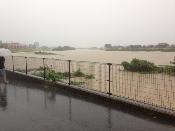
Even before the typhoon lands, Kanto Region and southern Tohoku have been experiencing heavy wind and rain since September 15.
At Fukushima I Nuclear Power Plant, the rainwater that had rapidly accumulated inside the 30-centimeter-high barrier around the RO waste water tanks went over the barrier in the afternoon of September 15. TEPCO is examining the water to see if it contains radioactive materials, according to Jiji Tsushin (9/15/2013).
The Typhoon 15 quickened the pace and traveled through Honshu and then Hokkaido, all's clear. Fuku-Ichi Hotel, aka Fukushima I Nuclear Power Plant survived. Not much rain and wind as had been feared.
Post-post typhoon water situation at Fuku-Ichi Hotel from Yomiuri Shinbun (9/21/2011):
東京電力は21日、台風15号の接近に伴う大雨の影響で、福島第一原子力発電所の2~4号機タービン建屋にたまった高濃度汚染水の水位が、午前7時から午後4時までの9時間で、13~18ミリ上昇したと発表した。
TEPCO announced on September 21 that due to the approaching Typoon No.15 the water levels in the turbine buildings for Reactor 2, 3 and 4 rose by 13 to 18 millimeters in 9 hours from 7AM to 4PM.
現状では地表に汚染水があふれ出す恐れはないという。
At the current rate, there is no fear of contaminated water overflowing, according to TEPCO.
一方、6号機のタービン建屋地下で、雨水とみられる毎時約4トンの漏水を発見。1、2号機の中央制御室近くの部屋でも雨漏りが見つかったため、監視を強化している。
Meanwhile, a leak of water at 4 tonnes/hour was found in the basement of Reactor 6 turbine building. It is considered to be the rainwater. Leaks were also found in the rooms near the central control room for Reactor 1 and 2. TEPCO is carefully monitoring the situation.
Or so it looks like, though no MSMs in Japan dare mention that.
Here's the map from Yahoo Japan typhoon information, and the location of Fukushima I Nuke Plant is marked with an arrow (courtesy of Savechild.net). The expected path of the typhoon looks almost directly over the plant.
According to NHK Kabun tweet, rainfall in 24-hour period in Shikoku, Kinki and Tokai region is between 300 to 400 millimeters (11.8 to 15.7 inches). Rainfall in Tohoku is exceeding 150 millimeters (5.9 inches).
NHK Kabun is also warning about storm surge in the coastal areas.
There are other nuke plants to worry about along the way, most notably Hamaoka Nuke Plant in Shizuoka Prefecture whose reactors somehow managed the "cold shutdown". From Fukushima I, we know that all it takes for a serious accident to happen at a nuke plant is for the cooling of the reactors to stop. If the power supply somehow get disrupted along with disruption in transport long enough (landslide anyone?), and the backup generators run out of diesel and backup batteries to simply die and they are not resupplied, well it doesn't need a Great Tokai Earthquake to wreck the plant, does it?
Another "why are they doing this?" moment for me. TEPCO is repairing the roof of Reactor 3's turbine building in preparation for the Typhoon No.6 so that the rainwater wouldn't go inside the turbine building.
Well, Reactors 1, 3, and 4 don't even have roofs on the reactor building. What difference would plugging the holes in the Reactor 3 turbine building make?
For this meaningless effort, 2 of the 4 human workers who installed the metal plate over the large, oblong hole on the roof received radiation exceeding 10 millisieverts. That's extremely high, considering the work was done outside, not inside the building, though there's no information as to how long the workers took to complete the task.
Now why would the rooftop be so radioactive for this particular turbine building? The holes look as if something heavy fell through the roof.
Only regional newspapers like Hokkaido Shinbun even had the radiation numbers for the workers. No such information in the national papers like Yomiuri and Asahi.
From Hokkaido Shinbun (7/18/2011):
東京電力は18日、福島第1原発で台風6号の接近に備え、3号機のタービン建屋の屋根に事故で開いた穴などを鉄板でふさいで雨の流入を防ぐ作業を進めた。長径14mの楕円状の穴をふさぎ終え、長径5mの穴と、事故でふたがなくなった換気口などを19日までにふさぐ予定。
TEPCO continued the work on July 18 to cover the holes on the roof of Reactor 3's turbine building with metal plates in preparation for the approaching Typhoon No.6. The workers finished covering the 14-meter diameter oblong hole, and will plug a 5-meter diameter hole and vents that lost the lids in the accident by July 19.屋根の上で穴に鉄板をかぶせる作業中の4人のうち1人が当初計画の10ミリシーベルトを超える12ミリシーベルトと11ミリシーベルトの放射線量を被ばくした。東電は「思ったよりも作業に時間がかかったため」と説明している。
Of the 4 workers who did the work on the roof, two received radiation exceeding the planned 10 millisieverts. One received 12 millisieverts, the other 11 millisieverts. TEPCO explained the reason as "the work taking longer than expected".
3号機のタービン建屋ではこのほか、屋根の雨水を落とす二つの穴も土のうでふさぐ。
In Reactor 3's turbine building, TEPCO plans to plug two holes with sandbags. (The holes used to have pipes that collected rainwater from the roof.)
with the central pressure at 910 hectopascal (=millibar). It looks set to hit the southwestern Japan, but it is possible that it veers north once it hits Kyushu or Shikoku.
I sure hope it won't go anywhere near Fukushima. While TEPCO and NISA may think Reactor 3 is totally safe for an earthquake, it may not be for a typhoon wind and rain.
For Japan Metrological Agency's forecast, go here.
If the typhoon No.2 dumps a whole lot of rain, they will overflow. Even if it doesn't, it looks just the matter of time.
From the Ministry of Economy, Trade and Industries (METI)'s press release (in Japanese) on May 28 on the Fukushima I plant conditions, "Water levels at trenches":
Reactor 2 trench water level:
5/7: 880 millimeters (34.65 inches) from the top of grating of the trench
5/14: 760 millimeters (29.92 inches)
5/21: 760 millimeters (29.92 inches)
5/28: 576 millimeters (22.68 inches)
Reactor 3 trench water level:
5/7: 820 millimeters (32.28 inches) from the top of grating of the trench
5/14: 720 millimeters (28.35 inches)
5/21: 640 millimeters (25.20 inches)
5/28: 431 millimeters (16.97 inches)
The top edge of the trenches is at the Onahama Peil (O.P., average sea level used for the plant) plus 4,000 millimeters. In other words, 4 meters (13.12 feet) above sea level.

Uh oh.
Japan Meteorological Agency forecasts heavy rain in Kanto and Tohoku areas on May 29 and 30 from a strong typhoon (Typhoon No.2; central pressure 960 hectopascal or millibar) coming up north from Amami Oshima (where the red circle is on the map above).
According to Mainichi Shinbun Japanese (5/28/2011), TEPCO admits that Fukushima I Nuke Plant is not ready for the typhoon, and apologizes for the lack of preparation for the wind and rain. The company has been spraying the special resin on the radioactive debris and dust at Fukushima I Nuke Plant for a month to prevent the spread of radioactive materials by wind and rain, but the spraying is only half-way done.
The Central Waste Processing Facility that has been storing the contaminated water from the Reactors 2 and 3 is near full, and the water levels in the trenches remain high. The Containment Vessels are leaking.

Join Amazon Prime 
Shop Amazon Warehouse Deals - Deep Discounts on Open-box and Used Electronics
![[Most Recent Quotes from www.kitco.com]](http://www.kitconet.com/charts/metals/gold/t24_au_en_usoz_2.gif)


 Tokyo Time


