Arnie Gundersen of Fairewinds Associates mentioned in the latest video, in passing, toward the end, that Fukushima I Nuke Plant has sunk about a foot (about 30 centimeters) and that the foundation of the buildings must have been damaged.
One of the readers of my Japanese blog that has the Japanese translation of the video got curious and did some research using the data from the government agency (the Geospatial Information Authority of Japan), and came to a conclusion that the area where the plant sits may indeed have moved quite a bit, not just vertically but also horizontally.
His conclusion:
Vertical: - 50 centimeters (it sank 50 centimeters)
Horizontal: 220 to 250 centimeters to the east.
The following is the findings of Dr. Shunichi Ono, a medical doctor in Kumamoto Prefecture in Kyushu, from his blog (original in Japanese; my translation). [My notes in square brackets]
(Dr. Ono's post begins)------------------------------------
[After mentioning Arnie Gundersen's comment about Fukushima I having sunk a foot]
If it is true, it's a big story. Large-scale land subsidence have already been reported in Iwate and Miyagi.
So I searched the Geospatial Information Authority of Japan (GSI) site, and found the following information (in Japanese). [It is a list of cities and towns in Iwate, Miyagi, and Fukushima and the size of the land subsidence in each.]
http://www.gsi.go.jp/common/000060316.pdf

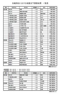
Overall, the land subsidence is between 20 to 80 centimeters.
The southern-most city on this list is Minami-Soma City in Fukushima Prefecture, located 20 kilometers north of the Fukushima I Plant. The land subsidence is 30 centimeters.
What about further south?
So I contacted the GSI and asked. Their answer was:
The results of measurement south of Minami-Soma City will be compiled by the end of this year;
There are electronic points of reference, and these results have already been made public.
http://www.gsi.go.jp/chibankansi/chikakukansi40005.html
Horizontal movement: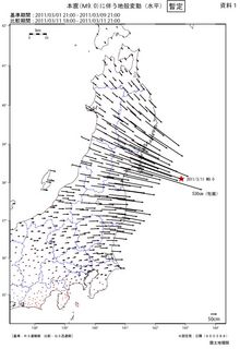
Vertical movement: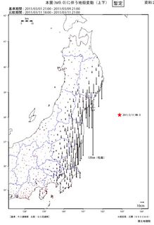
Map that plots the levels of movement [当変動量線図I do not know the official terminology], horizontal, Fukushima Prefecture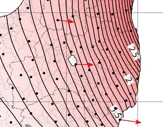
Map that plots the levels of movement, vertical, Fukushima Prefecture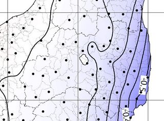
Fukushima I Nuclear Power plant is located about halfway along the Fukushima coastline. Checking the maps above, the ground underneath the plant may have moved:
Horizontal: 2 meters and 20 centimeters to the east;
Vertical: -40 centimeters (it sank)
(Update) Here's the map of Fukushima Prefecture.
Fukushima I Nuclear Power Plant is Located in Futaba-machi and Okuma-machi [red circle].
Fukushima II Nuclear Power Plant is located in Tomioka-machi and Naraha-machi [blue circle].
Again, looking at the maps above that shows the levels of movement,
Land subsidence at both plants: more than 50 centimeters;
Horizontal movement: between 220 to 250 centimeters (possibly distorting the ground).
These maps were created by the GSI; they are accurate, with the measurement error of 10 centimeters [for non-electronic points of reference].
If the ground shifted this much, I wonder if the foundation of the Fukushima Nuclear Power Plant has indeed sustained some grave damage.
The current seismic safety evaluation only uses ground motion acceleration (Gal, in cm/s^2):
mass * acceleration = force
This earthquake clearly brought about the distortion of the ground. Seismic safety evaluation should include the effect of land subsidence and horizontal movement. Needless to say, land subsidence and horizontal movement don't occur uniformly within the same plant compound.
Is it even possible to build a structure that wouldn't be affected by an earthquake that distorts the ground?
I suspect it is a given that the ground would not shift.
I think this is a serious problem.
(end of the post)----------------------------
Dr. Ono's bio says he once worked for TEPCO, before he quit and enrolled in a medical school. In his latest post (in Japanese), he diagnoses Japan's PM Kan and Nuclear Safety Commission chief Madarame as suffering dementia, based on their remarks about the state of the Fukushima I reactors.
The Geospatial Information Authority of Japan has an interactive map that shows the ground movements (vertical and horizontal). It's in Japanese only. Click on a red dot (point of reference), and you can see how much movement that point has experienced.


 Tokyo Time
![[Most Recent Quotes from www.kitco.com]](http://www.kitconet.com/charts/metals/gold/t24_au_en_usoz_2.gif)


4 comments:
In designing structures for earthquake resistance, one should find tie beams underground between the columns to transfer weight from one footing to another in the case of differential settling. Another option is to build a so-called floating foundation, where the building is essentially like a ship. The ground may move, but the building will move with it and the building internals (i.e. walls, columns, pipes, etc.) hopefully will not have much movement relative to each other. I think the latest design from Areva uses a floating foundation.
I was going to say the same as anon. but he beat me to it. Good work.
What he didn't mention is that designing a floating structure is significantly more expensive.
You can also build directly on bedrock:
http://www.chuden.co.jp/english/initiatives/eini_nuclearpower/enuc_earthquakemeasures/eear_bedrock/index.html
yuuanguu020
golden goose outlet
golden goose outlet
golden goose outlet
golden goose outlet
golden goose outlet
golden goose outlet
golden goose outlet
supreme outlet
golden goose outlet
golden goose outlet
Post a Comment